What if we used the ability certain animals have of finding their way and moving around to locate the north celestial pole? Simply by looking at the sky. This is possible thanks to the SkyPole method, developed by researchers at the Institut des Sciences du Mouvement Etienne-Jules Marey (Aix-Marseille Université/CNRS) and the Institut Matériaux Microélectronique Nanosciences de Provence (CNRS/Aix-Marseille Université/Université de Toulon).
Reading time: 4 minutes
|
Key points to remember:
|
Get inspired by nature to stay on track
How can you never lose your bearings? Today, the Earth's geographic north can be measured using four different instruments: a magnetic compass, a gyrocompass, or by using a camera to film stars such as the North Star, which is located near the north celestial pole (the imaginary point at the intersection between the Earth's axis of rotation and the celestial vault). Finally, it is possible to use a GNSS satellite positioning system (GNSS stands for Global Navigation Satellite Systems, like the American GPS). However, these four techniques have major drawbacks: the magnetic compass is very sensitive to electromagnetic interference, the gyrocompass is very expensive and relatively bulky, GNSS satellite signals can be easily scrambled or spoofed, and stars can only be used at night under clear skies.
As an alternative to these techniques, navigation strategies inspired by nature are particularly interesting, but also a source of innovation because they are relatively unknown. The Cataglyphis ant, for example, can estimate its course in the middle of the desert using its optical compass, combined with a region of its eye that is sensitive to the polarisation of the sky. This sky polarisation, invisible to the human eye, is linked to the phenomenon of Rayleigh scattering, which is responsible for the blue colour of the sky and creates a pattern of sky polarisation that can be used to locate celestial north.
Information about the degree and angle of polarisation of the sky is widely used in the animal world, but is currently under-studied by scientists. Studies have also shown that some migratory birds, such as the Indigo bunting and the Savannah sparrow, calibrate their magnetic compass by observing the celestial rotation at night, but also by day using the sky's polarisation.
A camera that detects the sky's polarisation patterns
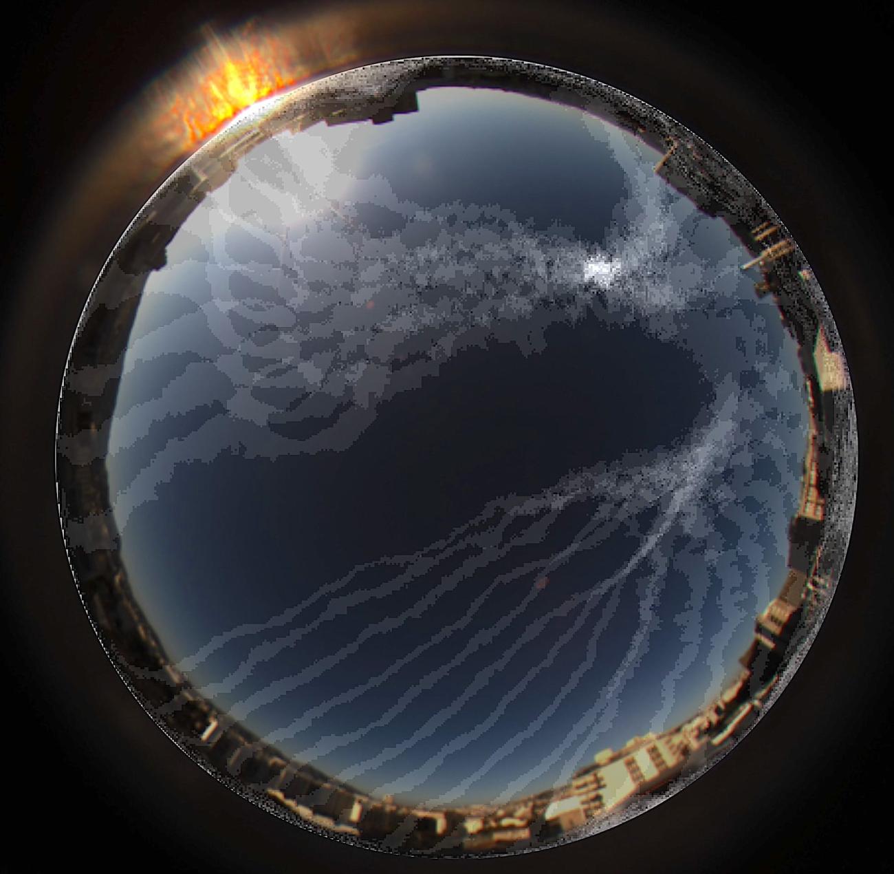
By drawing inspiration from living organisms, this study has led to the development of a bio-inspired optical method that makes it possible to find one of the two celestial poles ('north' or 'south') during the day. This method, called SkyPole, is based on the rotation of the polarisation pattern of light in the sky. The researchers involved used a camera sensitive to polarised light, known as a polarimeter, to measure the rotation of the degree of polarisation of daytime sky light. They then applied a successive difference of images taken at different times with the polarimetric camera to determine the position of the north celestial pole in the sky. This position makes it possible to calculate the latitude and true north bearing of the observer relative to the geographical north with an accuracy of a few degrees based on visual information alone.
SkyPole is the first method to only use information from the sky's polarisation pattern to geolocate and find your position in relation to the geographical north. Almost 300 years later, SkyPole is revisiting the sextant, a navigational instrument dating back to 1730 and co-invented independently by two people: John Hadley (1682-1744), an English mathematician, and Thomas Godfrey (1704-1749), an American inventor. SkyPole represents a first step towards the development of a "polarimetric" sextant. A patent has also been filed with the Société d'Accélération de Transfert de Technologies Sud-Est.
Figure: Panoramic view of the sky taken by polarimetric camera, highlighting the symmetries (white lines) of the polarization pattern intersecting at the celestial pole (brighter white point). The lines are the result of SkyPole processing.
Credits: © Thomas Kronland-Martinet, Léo Poughon and Stéphane Viollet
Contact à ajouter
Contact à ajouter
Contact à ajouter
Contact à ajouter
Contact à ajouter
Contact à ajouter
Reference: T. Kronland-Martinet, L. Poughon, M. Pasquinelli, D. Duché, J. R Serres and S. Viollet (2023) SkyPole - A method for locating the north celestial pole from skylight polarization patterns, PNAS.
Header image credits: © Thomas Kronland-Martinet and ESO/B. Tafreshi (twanight.org)
This article was published on October 10, 2023.
Discover also


Share on social media or