Where will we be able to grow vines in France in 2080? What will happen to the Svalbard ice cap? Which desert country could be covered by tropical forests by 2100? SimOn, the climate change simulator based on IPCC scientific models, helps you find the answers! Discover our interview with Joël Guiot, paleoclimatologist at CEREGE, co-president of GREC-Sud, co-coordinator of MedECC and author of the IPCC's special report on +1.5°C warming, who helped develop this project.
Reading time: 5 minutes
Fanny Trifilieff: How was SimOn developed?
Joël Guiot : SimOn (Simulateur On) was developed by the Cité de l'Environnement association, a non-profit organization created by two brothers, Hadrien and Clément Levard, with the aim of developing recreational tools to raise public awareness of environmental issues. These can take the form of games, digital tools, exhibitions or professional training materials.
The development of SimOn began with the realization that there was no easy-to-use, multi-scale (from the PACA region to global scale, for example), multi-parameter (biomes, temperatures, precipitation, rising sea levels) tool for simulating climate change based on the various scenarios of the Intergovernmental Panel on Climate Change (IPCC).
This global warming simulation tool stems from a collaboration within a multidisciplinary team of people committed to the fight against climate change. These include Corentin Leroux, whose interdisciplinary background helped transform and generate the data needed for the fine-scale maps; Macha Bellinghery, a scientific mediator, who made the model's various functions and complexities accessible to all; and Patrick Browne, a volunteer with the association, who oversaw the technical development of the current version to provide a fluid, intuitive user experience. The Cité de l'Environnement association's entire management team, Mathilde Mercier, as well as Hadrien and Clément Levard, also contributed. Last but not least, I myself took part by extracting the data from the IPCC climate simulations and supervising the development of the statistical calculations.
This project was carried out with the support of the A*Midex university foundation, initially via the Labex OT-Med, then completed as part of the ITEM institute, Mediterranean Institute for the Environmental Transition
F.T: How does it work?
J.G: The basic data are available to the public. We extracted them from the CMIP database, which is used to produce the IPCC projections. These projections are based on some twenty global climate models. We standardized the data and adjusted the spatial scale to produce global average maps. We have also calculated high-resolution maps that allow us to focus on France and the Provence-Alpes-Côte d'Azur region.
When the application is opened, a short tutorial explains how to vary the climate variables, scenarios and time horizon. The scenarios proposed correspond to IPCC forecast scenarios. There are three of them:
- The first, called the "optimistic scenario", is the one that moderates greenhouse gas emissions in line with the Paris Agreement.
- The second, the "intermediate scenario", does not respect the Agreement and is the one we are currently following.
- The third, the "pessimistic scenario", is the one where no effort is made, also known as "business as usual".
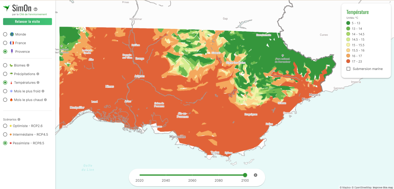
SIMON_pessimistic_scenario_2100
Illustration of temperatures in Provence in 2100, under the third "pessimistic" scenario: IPCC RCP 8.5. It corresponds to a temperature rise of over 4 degrees Celsius by the end of the century. It assumes that greenhouse gas emissions continue to rise at the current rate, without any significant reduction measures.
The time horizon varies linearly from 2020 to 2100, using either a manual cursor or an automatic animation. The user can start from the world map and focus successively on France, then on the PACA region. On the latter, we also project the areas that could be flooded as a result of rising sea levels. This rise is progressive according to the scenario chosen, from 40 cm to 90 cm in 2100. We also provide the distribution of vegetation (the major biomes) according to the corresponding climate. For example, Mediterranean vegetation can be seen moving northwards in France as the climate warms.
F.T: What are the objectives of such a project?
J.G : This free tool is aimed at anyone seeking to better understand the issues surrounding global warming, and we hope that it will raise awareness among as many people as possible, especially schoolchildren and students. It will also be made available as part of the Odysseo project for the future Musée de l'Environnement currently being developed in Marseille.
This tool is in no way intended for scientific research. It is intended for educational purposes only. We hope that it will enable everyone to understand the global and local challenges of climate change, and motivate them to transform their lifestyles to prevent our environment from becoming unliveable.
Glossary :
- IPCC : Intergovernmental Panel on Climate Change.
- GREC-Sud: Groupe d'experts Régional sur l'Evolution du Climat pour la Provence, Alpes, Côte d'Azur.
- CMIP: The Coupled Model Intercomparison Project (CMIP), which produces homogenized simulations on a global scale.
- Paris Agreement: Agreement signed in 2015 at COP21 in Paris, which encourages governments to do everything possible to limit global warming to less than +2°C compared with the pre-industrial era (late 19th century) and to do everything possible to move towards +1.5°C.
- Labex OT-Med : 2012-2020 AMIDEX/AMU project supported by the future investment program on environmental change in the Mediterranean region.
- ITEM: Mediterranean Institute for the Environmental Transition
Contact à ajouter
Informations complémentaires
Article published on November 23, 2023.
Discover also


Share on social media or